My introduction to Route 1 was arranged by my new boyfriend in the spring of 1976. With a meticulously detailed, hand-drawn map, complete with images of cows in front of Hilltop Steak House (Saugus) and the impressively tall and long stone wall bordering Parkland Avenue (and Pine Grove Cemetery) in Lynn , I nervously set out one Saturday morning. It’s doubtful that I had ever driven further north than Randolph, Massachusetts, and the soundness of my 1963 Rambler was always a concern. Granted, it was a solid piece of machinery and would likely have plowed over most other vehicles on the road — that is, unless the engine seized or I blew a tire, my greatest worries of the day. I pretty much stuck fast to that same course whenever I visited George or his dad from parts both south and north of there. In all the intervening years — 1976 to now — whenever I travel that path I think about that map, especially the cows and that imposing wall. It might have been one of the earliest signs that this guy was really into me.
Until I later moved with this boyfriend-cum-husband-cum-father-of-my-children to Salisbury in 1985, my feelings about Route 1 were clear and, frankly, immutable — I hated it. Drivers were the worst! None of the three lanes was safer or saner than the others. It wasn’t until I had a few travel experiences on Route 128 that I would cease to announce (to anyone who cared), “Route 1 is the worst road ever!” It’s even worse today, hardly shocking news.

But there’s another stretch of Route 1 that I came to know after we moved to Salisbury, and it’s a much friendlier, more soothing segment for the motorist. In fact, the section between Danvers and Salisbury — where it’s a single lane in either direction — in no way resembles the nightmarish part between Boston and Danvers. For those who reach that part alive, you’re graced with bucolic roadside scenery. The traffic lights in that stretch, given as gentle reminders to keep your speed moderate, have the added advantage of coaxing a pleasant examination of the surroundings. You can, as well, more easily contemplate the road’s origins.
If you’ve ever wondered about the naming of our roadways, your curiosity should begin with, why U.S. Route 1? Of all the numbered roads, being #1 is bound to be important. It may not be necessary to begin at the very beginning, when it was a mere trail system for travelers on foot, then horse-drawn cart, then stage coach. My own curiosity forms a halo around the persistence of the “Newburyport Turnpike” name. The turnpike era began in the final years of the 18th century, coinciding with a blossoming national sentience. With our struggles for independence a settled matter (by and large), our confidence as a new nation permitted us to turn our efforts toward long-term projects. With products being zipped all over and between the states, a tipping point had been reached; municipalities were finding it difficult to make improvements and regular repairs to public roadways. It does seem hard to fathom that once upon a time, road maintenance was 100% a local responsibility. (Think about that every time you pay a toll going over the Tobin Bridge or use the Mass. Turnpike.) Public charters, arrangements made between municipalities and private companies, acquired a decided appeal. And, even though their margin of profit ebbed and flowed in season with the rise and fall of other modes of popular transport, they can be credited with our roads’ finest hour in terms of maintenance. (Again, think about that each time your car hits a pothole.)
Returning to the naming of our roadways, before a consistent numbering convention was drafted in 1925, all the major roads bore names that reflected their uniqueness, as it were. But the states were suffocating beneath the ever-growing confusion of road names, not to mention the increasing traffic as Americans indulged their new passion. At that time, road names were much more evocative: the Dixie Highway, The Yellowstone Trail, and — of course — our own East Coast Highway, to which everyone along The Atlantic seaboard wanted to belong.
The really interesting piece in all of this is how the U.S. Department of Agriculture — in particular, its Bureau of Public Roads division — formalized the exact trajectory of the course that came to be called U.S. Route 1. I’d always assumed that the pathway that bears the name Route 1 was an obvious delineation, easily traced in red on an early 20th century Rand McNally road atlas, but with the clamoring interest up and down the Atlantic coast to be included, a definitive means of codifying needed to be established. There was instant approval of the idea advanced by E.W. James, chief of design for the BPR, that they use the historic “Falls Line” roadway network as a template. In the early days of our nation when cargo was moved by boat, communities were established as far upriver from The Atlantic as boats could safely reach, usually at the point where they encountered falls or rapids. To meet overland cargo transportation needs, a network of inter-city roads was established. Anomalies, inconsistencies and political outmaneuvering notwithstanding, that’s exactly the pathway that U.S. Route 1 followed, beginning in 1926.
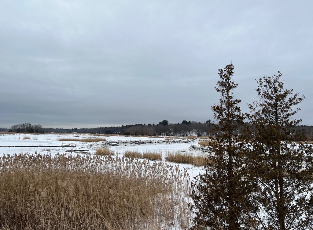
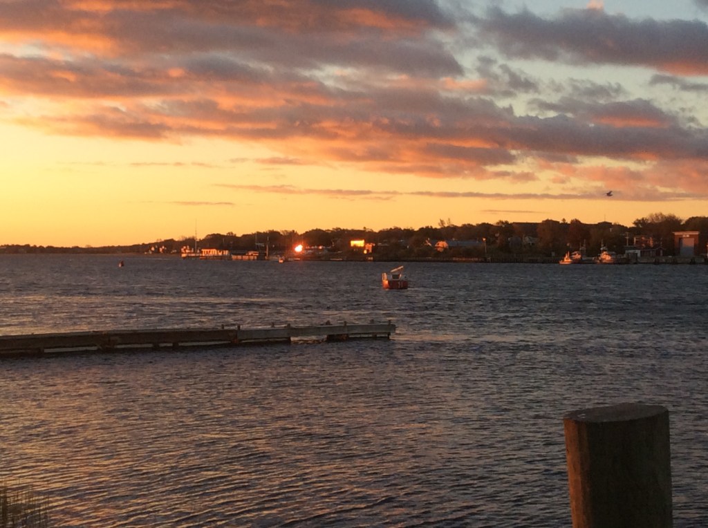
For all the years that I traveled back and forth to my teaching job at Triton High School in Byfield, Massachusetts, I never took for granted my commute along Rt. 1. I always rhapsodized about how easy and relaxing it was. Even though it would have been faster to take Route 95, I nearly always opted to go the slower road. For those of you thinking, Gawd, who would choose willingly that nightmare of a road? I point out that Rt. 1 between Danvers and Salisbury is a delightful departure from parts both south and north of there. In Topsfield, the way is bordered by old stone walls, behind which can be seen rolling meadows and antique farmhouses. Postcard worthy images, for sure. Further north (and part of my daily path), the marshland through which the Parker River flows was a constant source of pleasure, especially early in the morning. Each day, by the time I crested the hill above the Parker, I opened my mind to the anticipated landscape. Often, the mist was just beginning to dissipate, exposing the salt marsh hay stacks above a fleecy blanket of white-gray. Other times the mist traced a serpentine path directly above the river. And there were plenty of mornings, too, when the long shadows cast by the rising sun distorted all the features before me, creating a surreal canvas of darks melting into lights. No matter the season, there was joy in the scenery. With only three traffic lights between my house and school, and few cars on the road so early, I was pretty much alone with my thoughts for the twelve minute ride to work. Given how easily I was distracted by the landscape, it’s remarkable that I never crashed into anything. I was probably most at risk when I knew the sun would just be edging above the horizon as I crossed the Merrimack — I could never resist craning my neck at precisely the mid-point of the bridge. And I always always remarked — to no one other than myself — about how beautiful it was.
Inasmuch as I might entertain a sentimental wish that we could return to a more intimate era when our major roadways sported names that reflected regional character, such an invocation to revisit the past can provoke unpleasant consequences. Who, really, would think it wise — or sensitive — to reintroduce and perpetuate, for example, a highway that contains the word “dixie”, given the word’s association with a romanticized antebellum era? My wistful thinking is modulated further when I consider that the earliest (successful) efforts to name our “trails” were outcomes of merely the noisiest promoters of road names. It wasn’t any governmental body that affixed the names to our major roads up through the early decades of the 20th century. It was trail associations (with very defined motivations) who often competed for naming rights, and who — in fits of pique — might change the course of their routes and completely snub offending cities, making it all be known by slapping up new signage on barns, rocks, trees, or other visible objects. Say what you will about governmental interference, but the national systematizing of our roadways was an inarguable giant step forward. The fact that anyone can reasonably navigate from one part of the country to another is largely due to the imposition of a systematic and simple strategy — north-south routes were given odd numbers, east-west even numbers (with the more substantial transcontinental routes being further categorized: east-west were two-digits ending in zero, and north-south ending in either one or five.) Think of any numbered route and apply this formula — it works!
It is my great hope that you — loyal readers — don’t get overly mired in the nomenclature, and instead aim your car for destinations that provide ample roadside distractions. Even before I was retired and traveled the same 12 miles to work each day, I never ceased to be surprised by the landscape along Route 1. I’d like to think that roads aren’t empty, colorless lanes between point A and point B, but rather conduits to experience nature’s ever-shifting kaleidoscope of images. It’s worth it to leave for work just a few minutes earlier in order to luxuriate in the details that we’re forced to overlook when it’s a frenzied commute down the interstate. I’d like to think that for over twenty years I took a Sunday drive — every work day — so that I wouldn’t miss out on the blanketing mist that hovered over the Parker River flood plain or the occasional Northern Harrier who glided above it or the sun rising over the Merrimack, all images that bolstered me, centered me, imbuing each day with meaning and purpose. Such memories I hope to always hold dear.

I just loved reading this… your writing style is so much like my mother’s. It put me in mind of the beginning of the pandemic when nothing was open….everything was closed so Butch and I decided that we would chose a different route to follow every weekend….Rout 27N, Rout 44W, Route 2W, route 6W….. to just take a drive. We went through so many little beautiful towns that we had never been through. We would stop and grab a sandwich and a drink and just find a beautiful spot on the side of the road to enjoy the view. I really loved those drives….we should do another one.
LikeLike
Agreed! It doesn’t even need to be anything “grand”. Either way, there’s so much to see! (And I receive your compliment as high praise – your mom was a smart lady!)
LikeLike
Another great read!
Having traveled from Fort Kent to Key West. I have my own love-hate relationship with Rte 1.
It all boils down to: away from the cities, it’s some of the most beautiful US scenery to found east of the Mississippi. Within the cities, it’s some of the worst traffic you can encounter with red traffic lights seemingly at ever block.
My favorite parts are motorcycling north of Portland and any mode of transportation south of Homestead.
Least favorites are Baltimore to Alexandria and Fort Lauderdale to Homestead.
LikeLike
Knowing your wanderlust spirit, I was so hoping you would comment! Your perspective is so much broader than mine. Route 1 is definitely a road of multiple personalities.
LikeLike
Thank you. Your writing paints pictures.
LikeLike